Altazimuth System
The altazimuth, or horizontal, coordinate system describes the sky from the viewpoint of an observer on Earth. It is based on the visible horizon, treated as a plane passing through the center of the planet. Two key reference points define its vertical direction: the zenith, directly overhead, and the nadir, directly below the observer.
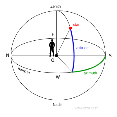
To locate a celestial object, the system uses two angular coordinates:
- Altitude
Altitude measures how high an object appears above the horizon. It is expressed in degrees, arcminutes and arcseconds, ranging from 0° at the horizon to 90° at the zenith. - Azimuth
Azimuth measures direction along the horizon. It is the angle between the South point and the vertical circle passing through the object, measured clockwise from 0° to 360°, increasing toward the West (W).
These coordinates change with the observer’s location and, at any fixed location, also change over time because of Earth’s rotation. For this reason, the altazimuth system is not ideal for cataloging stars. However, it excels at showing the sky exactly as it appears at a specific time and place, which makes it popular for direct observation and telescope use.
Practical example
At 10:15 p.m. in Rome, an observer points a telescope toward a star positioned halfway between the horizon and the zenith. Measuring the vertical angle gives an altitude of 45°.
The observer then traces the vertical circle passing through the star and measures the arc along the horizon starting from South, moving clockwise until the circle meets the horizon. The result is an azimuth of 220°.
In this case, at 10:15 p.m. in Rome, the star has coordinates h = 45° (altitude) and A = 220° (azimuth) in the altazimuth system.
In other words, the star appears 45° above the horizon in the northeastern part of the sky.
And so on.


