Positional Astronomy
Positional astronomy, or astrometry, is the most ancient branch of astronomy. Its purpose is to measure and describe the positions of celestial objects on the celestial sphere and to track their apparent movements as seen from Earth. Unlike other fields of astronomy that focus on the physical nature of stars and planets, astrometry is concerned with where these objects appear in the sky and how their positions change over time.
To map the heavens, astronomers imagine a large celestial sphere centered on Earth, onto which stars, planets and constellations are projected. The distances measured on this sphere are angular, expressed in degrees, arcminutes and arcseconds. This approach is essential because celestial objects are so distant that their true separation cannot be measured visually in kilometers. Positional astronomy therefore focuses on the apparent angular distance between objects, rather than their actual physical distance from Earth.
A key principle in this field is apparent motion. Due to Earth's rotation and its orbit around the Sun, celestial objects seem to move across the sky daily and seasonally. Spherical coordinate systems allow astronomers to pinpoint any object with precision, despite these continuous motions.
Celestial Coordinate Systems
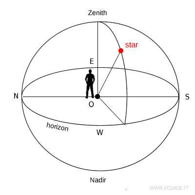
To locate objects in the sky, astronomers rely on several spherical coordinate systems, which act as three-dimensional maps of the celestial sphere. Every system includes:
- A reference plane passing through the center of the celestial sphere, ensuring consistent measurements from anywhere on Earth.
- Two angular coordinates, comparable to latitude and longitude on Earth.
- Two fixed reference points, known as poles.
In practice, determining a celestial position requires two values, just as a point on a flat map is defined by x and y coordinates.
Here are the main astronomical coordinate systems in use:
- Altazimuth (horizontal) system
Based on the observer's horizon, it uses altitude and azimuth to describe where an object appears in the sky. It is easy to understand because it reflects the sky exactly as we see it from Earth. Its limitation is that the coordinates change constantly with the apparent motion of celestial objects. - Equatorial system
The most widely used system in astronomy, it is based on the celestial equator and uses right ascension and declination. These coordinates remain nearly fixed and are the closest equivalent to longitude and latitude on Earth. - Hour-angle equatorial system
A variation of the equatorial system, it replaces right ascension with the hour angle, measured from the local meridian. It is especially useful for telescopes with equatorial mounts, since it follows the daily motion of the sky directly. - Ecliptic coordinate system
Based on the ecliptic, the path traced by the Sun throughout the year, it uses ecliptic longitude and latitude. This system is particularly important for studying the Sun, Moon and planets of the Solar System. - Galactic coordinate system
Centered on the plane of the Milky Way, it uses galactic longitude and latitude to map the structure of our galaxy and the objects within it.
Each system serves a different observational purpose, but they all share the same objective: to identify and communicate the exact position of celestial objects with clarity and precision.


