Equatorial Coordinate System
The equatorial coordinate system is one of the most widely used ways to pinpoint the position of stars and other celestial objects on the sky as seen from Earth. It provides a universal map of the heavens, allowing astronomers anywhere in the world to describe the same object with the same numbers. Each object's position is defined by two angles: declination and right ascension.
- Declination (δ)
Declination tells us how far north or south an object is from the celestial equator, measured along the meridian that passes through the object. The celestial equator is simply Earth's equator projected onto the sky. Just as latitude measures position on Earth, declination does the same in the sky: 0° at the celestial equator, +90° at the north celestial pole, and -90° at the south celestial pole.
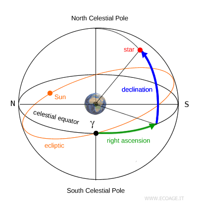
- Right Ascension
Right ascension (RA) measures how far east an object lies along the celestial equator, starting from a reference point called the vernal point (γ). It's measured in hours, minutes, and seconds, from 0 to 24 hours, increasing eastward (counterclockwise). A full 24-hour cycle corresponds to a complete 360° sweep of the sky.
What is the Vernal Point? The vernal point, also known as the gamma point (γ) or the vernal equinox, is where the celestial equator meets the ecliptic, the Sun's apparent yearly path across the sky. The name "vernal" comes from the Latin for spring: as seen from the Northern Hemisphere, the Sun reaches this point around March 20 - 21, marking the beginning of spring, when day and night are nearly equal in length.
Although the equatorial system is based on Earth's equator and poles, it remains fixed relative to the stars. As Earth spins on its axis, the coordinates of a star do not change, making this system ideal for cataloging celestial objects over time.
Because the system does not depend on where or when you observe, astronomers around the world can use the same coordinates to locate the same star. That's why the equatorial coordinate system is the standard reference in most star maps and observatory databases.
Over centuries, though, these coordinates slowly shift. This gradual change is caused by two main factors: the intrinsic motion of stars through space and the slow precession of Earth's rotational axis. Both effects are well understood and accounted for in modern astronomical calculations.


